 General Location. On Monte Sano Mtn., adjacent to Huntsville.
Length & Difficulty: 2 miles; easy.
Elevation Change: 200 feet maximum.
What’s Special: Interesting rock formation.
Topo Maps: Huntsville USGS 7.5 degree quad.
Getting There
Take I-565 into Huntsville and exit at Highway 431 (Governor’s Drive). Follow H431 to the crest of the mountains; turn left onto Monte Sano Boulevard. Drive approximately 2 miles and turn on Nolen Ave. Drive 1 mile to park entrance.
Description
This popular state park is directly adjacent to the Huntsville city limits. As a result parts of MSSP resemble a municipal park more than a state park. It has playgrounds, an amphitheater, a Japanese Garden, a general store and even a planetarium. On weekends the mountain top section of the park is usually crowded with city slickers out for a stroll. Take a short hike down the slopes, though, and you’re in another world. An excellent trail system runs along the northeast face of Monte Sano Mountain and over to adjacent Panther Knob. Other trails connect with the Huntsville Land Trust trail system and form a circuit around Monte Sano and Round Top Mountains. Stop by the park’s ranger station; they have a good map of all the trails on the mountain.
The Hike
The park has a large number of trails, all of which are well maintained. The Stone Cuts trail is the most interesting and is the one described below.
Finding the Trailhead: From the park entrance follow the road till it forks and keep to the left. The road will pass the ranger station and the general store. The road stops in a parking lot just past the planetarium .
The road continues past the overlook, but is blocked to car traffic. Walk down this road past a second overlook; begin looking for the trailhead to your right.
The trail winds down about 60 feet at an easy grade. When you reach bottom you will be in the saddle between Monte Sano and Panther Knob. Several trails cross here, so it’s easy to get on the wrong path. You will first reach a spot where three trails branch off from your path. Go straight. You’ll come to a second intersection almost immediately. Keep to the right. This isn’t as complicated as it sounds; just take the only trail that climbs from these two intersections.
The climb up Panther Knob is mild. A short side trail leads to the knob itself. The rocky knob is the highest point locally; you can see several trees which have been hit by lightning.
Return to the trail and continue on. You will now be walking along the top of the ridge. Keep an eye out for another branch trail to your left which seems to lead into some rocks; this will take you to the Stone Cuts.
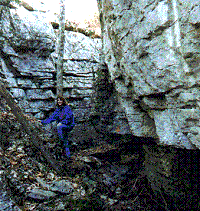
The Stone Cuts are a part of the hill’s capstone which has become exposed. Years of erosion have caused the limestone to split in two. The result is a fascinating rock formation. At one point the trail leads through a natural tunnel, and there are some tight squeezes throughout. A series of steps lead out of the cuts and back to the trail.
The trail soon turns down back into the saddle of Panther Knob. You will also see several sink holes in this area. This area is very popular with mountain bikers, so you might want to keep an eye out for them. No prejudice here: we’ve spotted mountain bikers doing maintenance on the trail too.
The number of trails in this area here give you several choices to return to the foot of Monte Sano. Take any one of them. Climb back up the mountain the way you came down.
More Information
Monte Sano State Park
5105 Nolen Avenue
Huntsville, Alabama 35801
(256) 534-3757
Facilities
- Cabins
- Full Hook-up RV Sites
- Camping Sites
- Bath House
- General Store
Safety
Though Monte Sano State Park is practically in the Huntsville city limits, this is a nature area with all the associated dangers. I’ve twice seen snakes in the Stone Cuts (neither of them poisonous). Please exercise care when passing through the rock formation.

Leave a Comment