Length (one way): 2 miles
One Way Trip Time: 2 hours
Trail Begins: End of Harbor Mountain Road.
Trail Ends: Where the trail joins Gavan Hill Trail, at a peak with elevation of 2505 ft. (see map)
Trail Rating: Moderate. Some sections are muddy and steep. Bears may be present.
Recommended Season: Spring-Summer-Fall
USGS Maps: Sitka A-4, A-5
Elevation Gain: 500 ft.
Access: Go approximately 4 miles northwest of Sitka along Halibut Point Road and turn right onto Harbor Mtn. Road. (Harbor Mtn. Road is after Shuler Drive) The road winds 5 miles up Harbor Mountain gaining 2000 feet elevation. This is a steep climb with sharp switchbacks. Recreational vehicles and vehicles towing trailers should not attempt the drive.
History: The road was built during World War II to provide access for building a lookout and other military installations at the top of the mountain.
Special Features: This is the only subalpine area in southeastern Alaska that is accessible by road. Wonderful vistas of Sitka Sound, Sitka, Mt. Edgecumbe, and numerous other mountains and islands can be seen from the road and trail. This trail connects with the Gavan Hill Trail, which terminates in Sitka on Baranof Street.
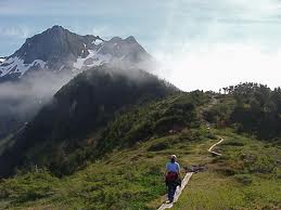
Description: The trail begins at the end of Harbor Mountain Road. The trailhead is marked by a bulletin board and hand railings, and proceeds up the hillside in a series of switchbacks, gaining 300 feet in elevation. At the ridge, a short spur trail leads to the left to an overlook. The main trail turns to the right and follows the ridge toward the summit of a knob where W.W.II lookout ruins are located. Before reaching the summit, however, the trail turns east and runs along the sidehill of an immense north-facing sub-alpine meadow. The trail then follows along a ridge toward the peaks of Harbor Mountain. The view from this ridge is spectacular – mountains, deep valleys, alpine rock fields and high rocky peaks of Harbor Mountain. The trail then forks off to the right and skirts the hillside. From here, on a clear day the Gavan – Harbor Mountain Hut (shelter) is visible nestled atop the flattened ridge to the east. As the trail levels out, rock cairns (piles) mark the way across a rock slide, linking to a visible gravel trail which leads to the hut and connects with the Gavan Hill Trail.


